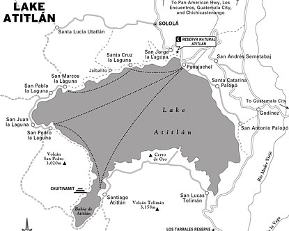
Use the map of Lake Atitlan to get facts on the locations of towns such as Panajachel and Santiago Atitlan, plus the natural features surrounding one of Guatemala's most popular attractions. For tips on other things to see and do in the area, read about the history of Lake Atitlan or check out the Guatemala map.
Lake Atitlán is the Guatemalan highland lake that Aldous Huxley called the most beautiful in the world — a volcanic caldera 1,560 metres above sea level, ringed by three volcanoes and twelve Maya villages, each with its own language, textile tradition, and market day. The light on the water changes every hour. The kayaking is excellent.
Map of Lake Atitlan: Must-See Experiences
- Panajachel market & Calle Santander
- Santiago Atitlán — Maximón folk saint shrine
- San Juan La Laguna weaving cooperatives
- San Pedro La Laguna backpacker scene
- Volcano hike — San Pedro or Indian Nose
- Kayaking across the lake
- Boat taxi between the villages
- Santa Cruz La Laguna — diving in the lake
- Cerro de Oro viewpoint
- Mayan weaving workshop participation
Explore by Region
Photo Gallery
Explore Guatemala
Frequently Asked Questions
Nov–Apr: dry season, clear volcano views, calm morning water; May–Oct: lush green hills, afternoon winds, fewer crowds
2–3 days: Panajachel + 2 villages; 4–5 days: full lake circuit, volcano hike; 6–7 days: add diving, weaving cooperatives, slow village rhythm
Panajachel, Santiago Atitlán, San Juan La Laguna, San Pedro La Laguna, Santa Cruz La Laguna
Panajachel (main hub, Calle Santander market), San Pedro (budget base), San Juan (cooperative stays), Santa Cruz (diving, quiet)
Day1–2 Antigua, Day3–4 Lake Atitlán, Day5–7 Tikal extension