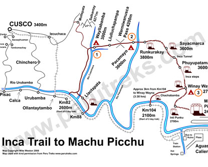
Use the Inca Trail map to find out about the location of major sites along the trail, including mountains, towns, and the Aguas Calientes hot springs, as well as the elevations of various spots along the Inca Trail. Click on the links to the left to find out about Machu Picchu and Inca Trail tours, as well as how to get to Peru.
Explore by Region
Photo Gallery
Explore Peru
Frequently Asked Questions
Dry season May–October: clear skies, firm trails; June–August peak crowds; April/November shoulder months, fewer hikers, occasional showers
4 days: classic Inca Trail to Machu Picchu; 5 days: add Aguas Calientes soak; 7+ days: extend with Sacred Valley, Ollantaytambo
Classic Inca Trail, Sacred Valley, Aguas Calientes, Machu Picchu citadel, Dead Woman's Pass high altitude zone
Aguas Calientes (trail base, hot springs access), Ollantaytambo (km 82 trailhead start), Cusco (acclimatization hub, permits)
Day1 Lima, Day2 Cusco acclimate, Day3 Sacred Valley, Day4 Machu Picchu, Day5–6 Cusco