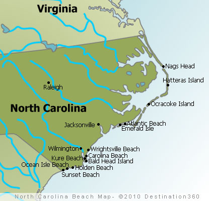
The Outer Banks are one of the best destinations for beaches along the Atlantic Coast, with amazing spots such as Cape Hatteras, Sunset Beach, and Bald Head Island. Click on the links on the North Carolina beaches map to find articles on these destinations, as well as beach hotels and the best things to do.
North Carolina is where the Wright Brothers first flew, where Blackbeard the pirate met his end, and where the Appalachian Trail reaches its southern terminus. It is a state of firsts, beauty, and barbecue debates that have never been fully resolved.
North Carolina Beaches Map: Must-See Experiences
- Blue Ridge Parkway scenic drive
- Biltmore Estate, Asheville
- Wright Brothers National Memorial
- Cape Hatteras National Seashore
- Great Smoky Mountains (NC side)
- Appalachian Trail, Clingmans Dome
- Outer Banks barrier islands
- Old Salem historic district, Winston-Salem
- Chimney Rock State Park
- Grandfather Mountain Mile High Swinging Bridge
Explore by Region
Photo Gallery
Explore North Carolina
Frequently Asked Questions
Spring: wildflowers + mild OBX temps; Summer: Outer Banks peak beach season; Fall: Cape Hatteras surf + fewer crowds; Winter: quiet barrier islands, low rates
2–3 days: Outer Banks core (Nags Head/Hatteras); 4–5 days: add Bald Head Island + Sunset Beach; 6–7 days: full NC coast loop
Outer Banks, Cape Hatteras National Seashore, Crystal Coast, Brunswick Islands, Bald Head Island
Nags Head (OBX hub), Duck (quieter north OBX), Ocracoke Island (ferry-access seclusion), Sunset Beach (Brunswick), Bald Head Island (no-car retreat)
Day1 Nags Head beaches + Wright Brothers Memorial, Day2 Cape Hatteras Lighthouse + Ocracoke ferry, Day3 Crystal Coast, Day4 Sunset Beach, Day5 Bald Head Island